EQuIS Geotech
Automate ♦ Standardize ♦ Centralize
Comprehensive Geotechnical Data Collection, Analysis, and Reporting
Experience the power of EQuIS Geotech!
Modernize and automate geotechnical data management
Standardized and Centralized Data

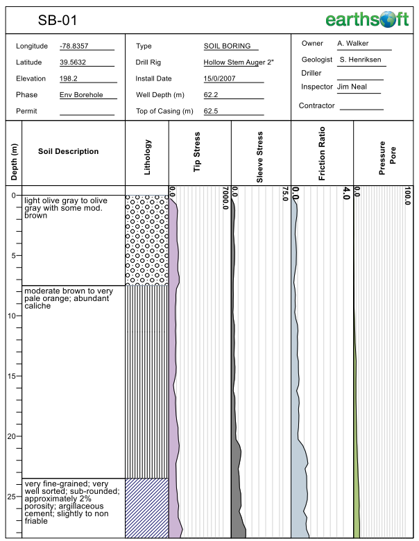
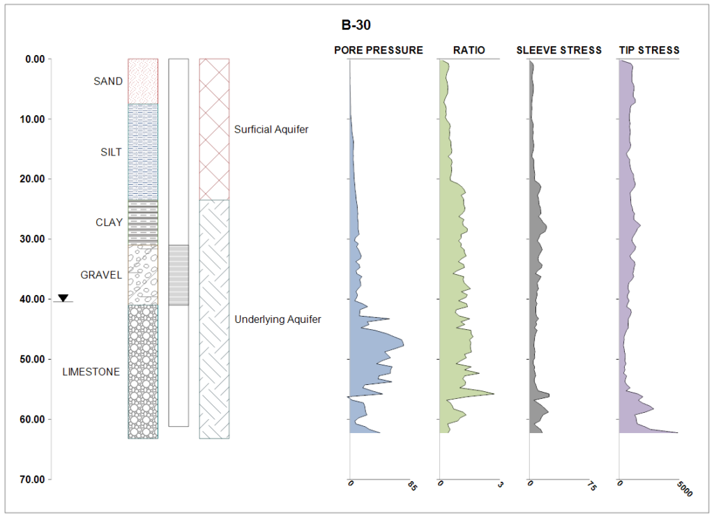
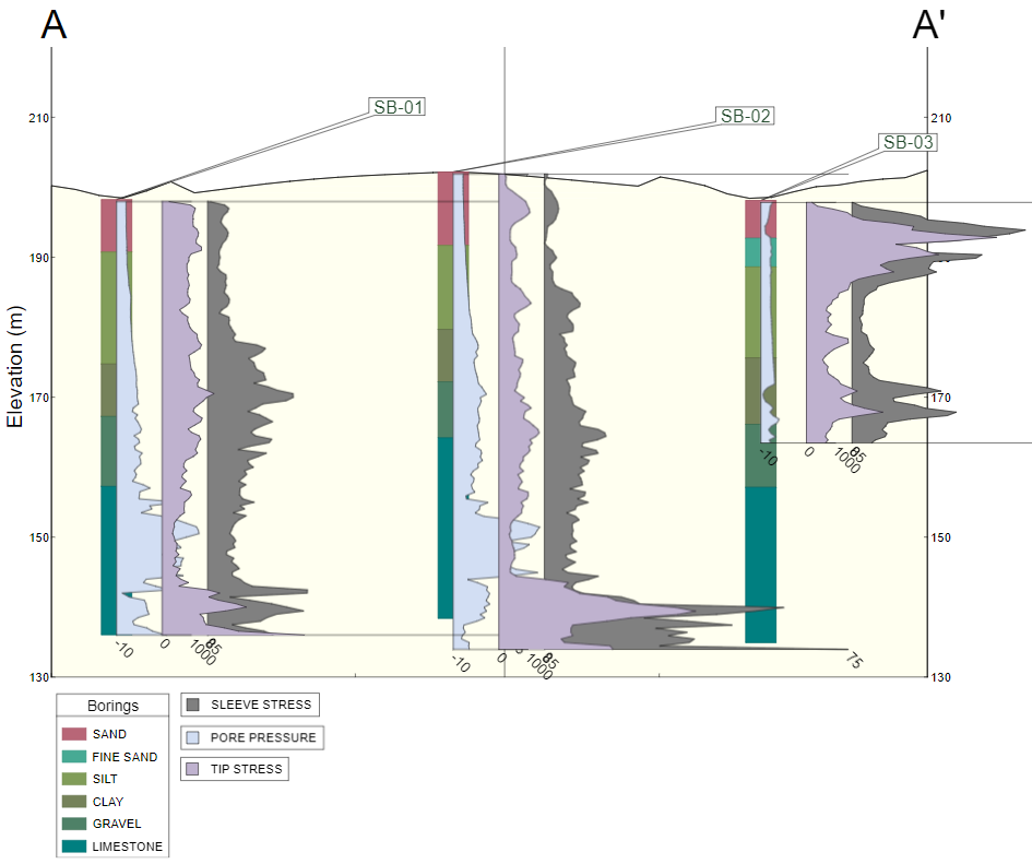
Boring Logs and Subsurface Profiles

Built-in Standard Reports and Forms

Built-in Dashboards for Data Entry and Analysis

EQuIS Geotech extends the EQuIS software suite and manages geotechnical and environmental data in a single enterprise solution. EQuIS Geotech provides web forms for data entry, customizable reporting templates, and geotechnical-specific workflow components. Numerous native EQuIS data operations are integrated, including migration capabilities and visualization tools. EQuIS Geotech improves data quality and streamlines project workflows for large-scale geotechnical data management.
EQuIS Geotech Workflow


Project Planning
- Setup project information
- Project planning workflows include standard EQuIS project setup and optional connections to client applications using REST API
- Prepare exploration plans, including proposed boring locations, methods, and depths (etc.)
- Schedule and disseminate the exploration plans to the field crew

Field Activities & Data Collection
- Capture drill sample information on paper or with EQuIS Collect
- Field logs are entered into browser-based Web Forms, conforming to organizational data standards
- Load cone penetrometer test (CPT) and dilatometer test (DMT) data
- Web Forms are configurable for efficient data entry and various data types


Boring Log Data Review
- Quickly generate soil boring logs and profiles, CPT logs, and DMT logs to review subsurface site conditions
- Map and grid-based filtering to review boring log data
- Review and modify data to reflect observed subsurface conditions

Lab Assignments & Testing
- Assign required lab testing based on project requirements and observed field results
- Assign labs and associate corporate, regional office, or project lab fees
- Lab forms support electronic import or hand entry of lab results
- Store raw lab data and reporting calculations directly in EQuIS Geotech
- Lab data review templates include Atterberg limit, grain size, water content, and more


Instrument Data
- Batch load instrumentation data files using configurable data templates
- Review and report UU/UC and more

Analyze Visualize & Report
- Review and analyze data through multiple reports and templates
- REST API integrations with Esri’s ArcGIS for spatial analysis and reporting
- Produce presentation quality deliverables fit for final reports

Standard Reports
- Boring, CPT, and DMT Logs
- Subsurface Profile
- AGS4 Export
- Atterberg Limits – ASTM D4318
- Particle Size Analysis – ASTM D422
- Sieve Analysis – ASTM D6913
- Hydrometer Analysis – ASTM D7928
- Unconfined Compression – ASTM D2166
- Unconsolidated Undrained – ASTM D2850
- Compaction – ASTM D698/D1557
- Grain Size Analysis – AASHTO T-88
- Geotechnical Lab Summary
- Geotechnical Lab Forms
- gINT Export
- and more….
Ready to try it?
Features
- Modular, scalable, repeatable workflows for multi-project portfolios
- Supports raw lab data and incorporates industry standard ASTM calculations
- Import/export EQuIS data in an AGS v4.0.4 format
- Produces industry standard geotechnical boring, CPT, and DMT logs
- Built-in reports designed to mimic industry standard formats
- Direct data entry workflows with Web Forms, EQuIS Collect Forms, or EDDs
- Open Systems Model – REST API supporting various third-party integrations
Benefits
- Scalable, supported enterprise geotechnical data management solution
- Easily generate boring logs from EQuIS EnviroInsite, Collect, Professional and Enterprise and in Esri ArcGIS Pro using ArcEQuIS
- Planned EQuIS release schedule keeping pace with newest technology standards
- Developed through collaboration with industry leaders
- 25+ years of EQuIS client-driven development and client-focused support
Standardized and Centralized Data

Boring Logs and Subsurface Profiles

Built-in Standard Reports and Forms

Built-in Dashboards for Data Entry and Analysis

Watch our introductory video to see how EQuIS Geotech can improve your geotechnical data management workflows!
Gallery
Take a quick tour!
- All
- Boring Logs
- Field Activities
- Instrument Data
- Lab Data
- Reports
- Subsurface Profiles

Request More Information
Fill out our contact form and one of our sales representatives will contact you shortly!


