
EDGE
Accurate and Complete Field Data Collection
EQuIS Data Gathering Engine (EDGE) is a comprehensive collection of integrated environmental field tools ensuring accurate and complete data collection using modern software and mobile computing technologies. EDGE contains an integrated GPS mapping interface, electronic Chain of Custody generator, and a field EDP interface that enable users to generate, attach, and view image, voice and other common file formats. EDGE includes an EDD generator and much more.
EDGE Features include: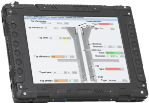
- Integrated offline data collection with EDP checks, connecting forms to formats
- Comprehensive field forms library and configurable custom forms, tied to EDD formats
- Integrated EDP checks and calculations against standards, for multiple forms and formats
- Integration with a wide array of data loggers
- GPS location and mapping
- Attach drawings, voice memos, and files
- Digital Sign and Submit to EQuIS Enterprise for secure data transactions
- Historical water level and LNAPL data comparisons
- Configurable COC templates
- eCOC specifications and exports in both XML and Excel formats
- Label printing with barcodes
- Merge Field EDDs, files and photos offline from different devices
- SPM workflow integration

EDGE smart form – built in checker

EDGE GIS and mapping functionality
Solutions
Want to Learn More?
Explore EQuIS Environmental Data Management Workflows
Contact Us
125 S. Alcaniz St., Suite 2
Pensacola, FL 32502
800.649.8855
info@earthsoft.com
Subscribe to Our Mailing List
Stay informed about our upcoming events, news,
and more.