
EnviroInsite
EQuIS Data Visualization
EQuIS™ EnviroInsite is environmental and geotechnical data visualization software for hydrogeologists, environmental scientists, and engineers that has capabilities to:
- Create and display site maps using images and/or vector file formats;
- Visualize two-dimensional (2D) and three-dimensional (3D) environmental data;
- Generate customized boring logs and strip logs;
- Analyze stratigraphy in cross-sections and/or complex 2D or 3D geologic models;
- Evaluate geochemistry;
- Conduct statistical analyses; and
- Prepare customized report graphics that can be exported as PDF, CAD, or GIS files.


EnviroInsite connects directly to EQuIS to access data, eliminating the need to transfer or restructure data. Esri’s ArcGIS Online Map service or Microsoft’s Azure Maps service may be accessed to provide basemap images (aerial photos and road map images). EnviroInsite can also serve as a Web Mapping Service (WMS) client, so users can automatically obtain aerial images and other mapped data from many public WMS servers. EnviroInsite easily imports and exports Esri shapefiles, AutoCAD files, and other image file types.
EnviroInsite helps evaluate constituent values with time series charts, radial diagrams, scatter plots and pie charts. The various plot types allow for the selection by constituent(s), sample media, elevation, depth, and date. Aggregate functions can be called to permit calculation and plotting of mean, maximum, minimum, first, or last values. Geochemistry can be analyzed using Piper diagrams, Stiff diagrams, and Schoeller diagrams.
Understand complex spatial and temporal relationships in your environmental data with EQuIS EnviroInsite. Mapped environmental data includes 2D and 3D contours, 3D surfaces, wells, sample locations, posted data, classed post plots, and georeferenced diagrams and charts. Fence diagrams, strip logs, particle tracking, and geologic modeling enable understanding of the hydrogeologic setting.
EnviroInsite’s intuitive user interface makes it the perfect data visualization software for any environmental professional.
Case Studies
Groundwater Quality
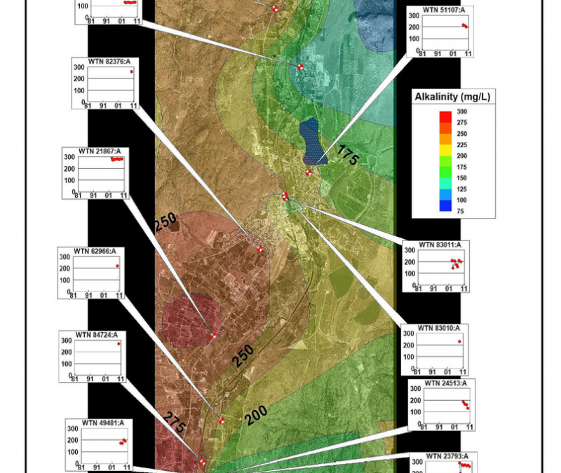
Project Details Western Water Associates was tasked with analyzing groundwater chemistry data, recommending modifications of monitoring networks, and enhancing the capability of client staff to interpret data and present...
Water Resources Planning
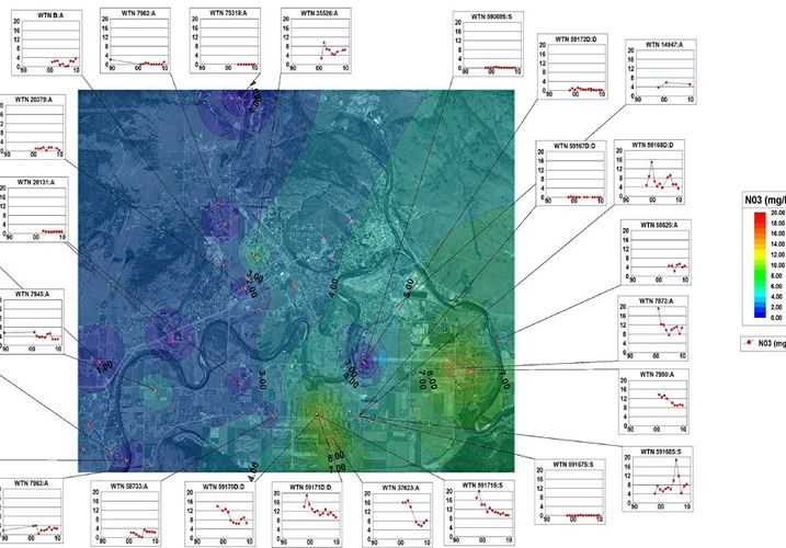
Project Details Piteau Associates was tasked with developing a plan for preservation of water quality of public water supply wells within the community of Grand Forks, Columbia. They constructed a database of water...
Natural Attenuation
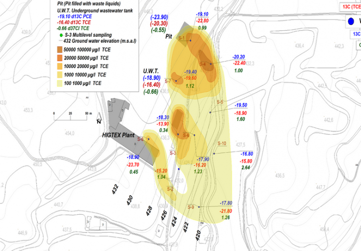
Project Details Researchers at Universitat de Barcelona and University of Waterloo made use of EnviroInsite’s advanced data visualization capabilities to contour hot-spots of TCE contamination and carbon isotopes. The...
- All

EnviroInsite CPT Boring Log

EnviroInsite Geotechnical Boring Log

EnviroInsite Boring Log with Well Diagram

3D Analyte Contours in EnviroInsite

EnviroInsite Box and Whisker Plot

EnviroInsite Cross-section with Analyte Contours

EnviroInsite Cross-section with CPT and Lithology

EnviroInsite Map with Analyte Contours and Aerial Photo

EnviroInsite Map with Stiff Diagrams

EnviroInsite Map with Pie and Time Series Charts

EnviroInsite Time Series Charts

EnviroInsite Map with Action Level Callout Tables

EnviroInsite Schoeller Diagram

EnviroInsite Strip Log
EnviroInsite Time Series Charts

EnviroInsite Map with Analyte Contours

EnviroInsite Analyte Contour Cross-section

EnviroInsite CPT Cross-section

EnviroInsite Stratigraphy Cross-section with Water Levels

EnviroInsite Stiff Diagram

EnviroInsite Piper Diagram
Solutions
Want to Learn More?
Explore EQuIS Environmental Data Management Workflows
Contact Us
125 S. Alcaniz St., Suite 2
Pensacola, FL 32502
800.649.8855
info@earthsoft.com
Subscribe to Our Mailing List
Stay informed about our upcoming events, news,
and more.